The flysch de Zumaia coastline is one of those rare places where scenery and science pull in the same direction. The cliffs around Zumaia turn a walk, a beach stop, or a boat trip into a close look at layered sedimentary rock, a coastline shaped by tides, and one of the most important geological records in northern Spain.
In this guide, I focus on what makes the area worth visiting, which viewpoint or route fits different kinds of travellers, and how to time the trip so you actually see the best of the cliffs rather than just glance at them from afar. If you are planning a coastal stop in the Basque Country, this is the practical version that helps you decide where to go first and what to skip.
What matters most before you go
- The coastline sits inside the Basque Coast UNESCO Global Geopark, and the rocks record more than 50 million years of Earth history.
- Low tide is the key timing detail if you want to see the wave-cut platform and the full structure of the cliffs.
- The easiest first stop is the San Telmo and Itzurun area; the fuller coastal walk is about 14 km and takes roughly 4 hours.
- If you are short on time, the viewpoints and the short Algorri route give you the strongest return for the least effort.
- For a budget-friendly visit, the free viewpoints and shore walks are usually enough to understand why this coast is famous.
Why these cliffs are more than a pretty view
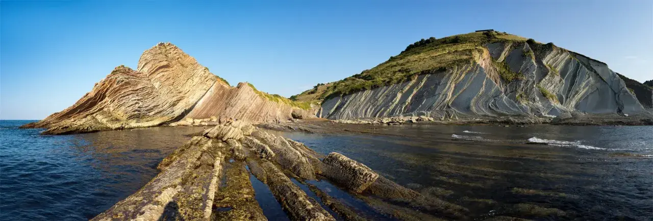
I like to think of the Zumaia flysch as a book made of rock. The alternating layers of sandstone and mudstone were laid down over millions of years, then tilted and exposed by later tectonic movement and erosion, so what was once seabed now stands almost like a vertical archive. According to the Basque Coast Geopark, the short Algorri route starts from San Telmo chapel and condenses over 50 million years of history into a walk of just 1.52 km and around 40 minutes.
That is what makes the place feel different from a normal seaside stop. You are not just looking at a dramatic cliff line; you are reading a geological record that includes major climate shifts and the extinction of the dinosaurs 66 million years ago. The value for visitors is simple: the science is visible without needing specialist equipment, and that makes the coast unusually rewarding even for people who are not geology fans. Once you understand that, the next question is obvious: where should you stand to see it properly?
Which way to see it gives the best experience
I would not treat every Zumaia visit the same way, because the experience changes a lot depending on whether you stay above the cliffs, walk the shoreline, or see them from the water. If you only have a short stop, choose the easiest format that still lets you read the landscape. If you have a full half-day, combine two or three views instead of trying to do everything at once.
| Experience | Time needed | What you get | Best for | Main trade-off |
|---|---|---|---|---|
| San Telmo and Algorri walk | 40 to 60 minutes | Close-up layers, the chapel, and the strongest low-tide views | First-time visitors and short stops | Depends on tide timing |
| Route of the viewpoints | 45 minutes to 2 hours | Broad panoramas and easy access from nearby parking | Families, mixed groups, low-effort sightseeing | Less detail than the shore level |
| Full Flysch Route from Zumaia to Deba | About 14 km / roughly 4 hours | The fullest coastal experience and the clearest sense of scale | Hikers and people with a half day to spare | More physical and less flexible |
| Guided boat trip | A few hours | A sea-level perspective that changes how the cliffs read | Photographers and travellers who want a different angle | You follow the schedule instead of your own pace |
My own rule is simple: start on land, then decide whether to add the sea view. The cliffs make more sense when you first see their height from above and then their texture from below. That mix is what turns a scenic visit into a memorable one, and it leads straight into the one detail that matters most in practice: timing.
How to time the visit around tides and weather
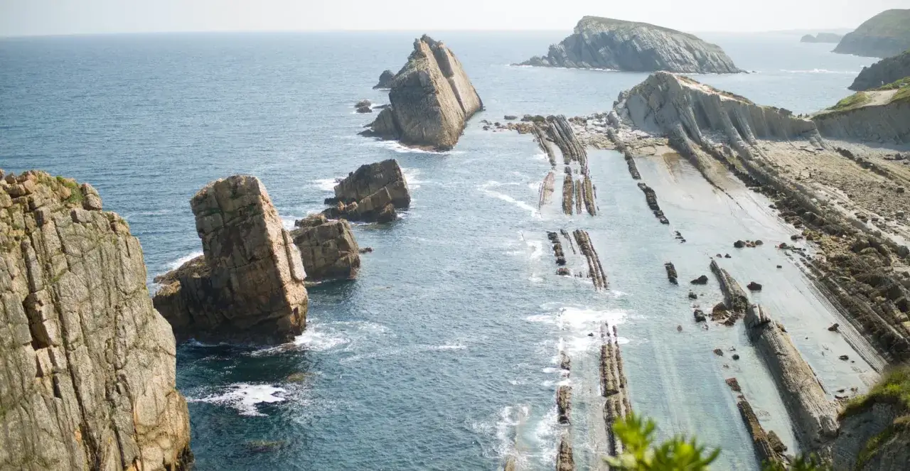
If you want the coast to look its best, low tide matters more than almost anything else. The offshore platform is exposed then, which is when the layered rock, the erosion patterns, and the scale of the coastline become much easier to understand. The official viewpoint route highlights Algorri especially at low tide, and the Sakoneta area is at its best then too. On the other hand, if the tide is high, the views from the higher lookout points still work well, so you do not need to cancel the day if your schedule is fixed.
Tourism Euskadi notes that Itzurun Beach is 270 metres long, close to town, and exposed to strong swell, which is useful context if you are planning to spend time at sea level. I would bring grippy shoes, a windproof layer, and enough time to slow down. Early morning or late afternoon usually gives the rock layers better light, and that small change can make the whole coast feel more three-dimensional. If you are travelling on a budget, this is also where the trip stays easy: the best viewpoints and shoreline walks do not require a big spend, only sensible timing. Once that is sorted, the surrounding stops become much easier to fit in.Nearby stops that make the coast day feel complete
One reason I recommend Zumaia so often is that it does not need to stand alone. The wider coast gives you several ways to build a better day without turning the trip into a rush. The Basque Coast Geopark is made up of three towns - Zumaia, Deba, and Mutriku - and that makes it natural to treat the flysch as part of a larger coastal route rather than a single viewpoint.
- San Telmo chapel and Itzurun Beach give you the most recognisable first look, and the chapel sits right over the flysch cliff, which makes the setting feel immediate rather than staged.
- Algorri is the best short educational stop if you want the basic story before you walk farther. It is compact, direct, and ideal when you do not want to commit to the full route.
- Elorriaga viewpoint is the place I would choose for scale. The panoramic angle helps you understand how high the cliffs actually are and how broad the abrasion platform becomes below them.
- Sakoneta-Mendata is the wilder option. If you are willing to walk more and the tide is right, it gives you coves, cliffs, and one of the most impressive rocky platforms on the coast.
- Deba and Mutriku are worth adding if you want a fuller coastline story. Deba extends the geology westward, while Mutriku pairs naturally with a guided boat trip and a more traditional harbour atmosphere.
If I had to narrow it down, I would say the smartest day trip is not the one that covers the most kilometres. It is the one that gives you one strong shore-level view, one broad viewpoint, and one nearby town stop that breaks up the geology with a bit of human scale. That is what keeps the visit interesting rather than repetitive.
The version of the visit I would choose first
For a first visit, I would do a low-tide morning at San Telmo and Itzurun, follow a short Algorri walk, and then finish at a viewpoint such as Elorriaga. That sequence gives you the coastline in the right order: first the rock at your feet, then the broader structure, then the panorama that explains why the whole place matters. It also works well if you are short on time, because you can still build a satisfying visit in under half a day.
If you have more time, the full 14 km Flysch Route is absolutely worth it, but I would not make it the default choice for every traveller. The shorter routes are easier to fit into a wider Basque Country itinerary, and they still deliver the core experience: the sense that this coast is both a landscape and a long geological timeline. That is the real strength of Zumaia - it rewards both the casual stop and the deeper look.